Mid-Atlantic Ocean Data Portal Winter Update
MARCO has added dozens of new maps to the Portal’s oceanography, fishing, renewable energy, maritime and marine life themes and made some major enhancements to its mapping tools at the request of users. Scroll below for highlights and click on the links for more information about these improvements.
BOEM NY Bight Final Sale Notice Areas (2022): Examine six areas off the New Jersey-New York coast that will be up for bid in a federal offshore wind energy lease sale on Feb. 23.
Private Groups and Drawings Tool Upgrades: Portal Group creators now have greater control over who can join them and view the bookmarked maps and drawings shared within them. Administrators can now set Groups to private, delete members, answer requests to join, and promote members to a “manager” role that allows them to delete or promote other members. In addition, registered users can now create, save and share points and lines in addition to polygons with the Drawings tool. The November edition of our “How Tuesday” webinar series provided a tutorial on using these and other advanced tools on the Portal.
MARACOOS Bottom Temperature Monthly Slider: Toggle through or automatically animate this series of maps that estimate average monthly sea bottom temperatures in ocean and estuarine areas from Nova Scotia to Cape Hatteras.
Recreational Fishing: Party/Charter 1996-2015: The Portal’s longtime Recreational Fishing: Party & Charter map, which was based on 2000-09 vessel trip report (VTR) data, has been retired and replaced by four higher-resolution maps created in the same style as the “Communities at Sea” VTR commercial fishing datasets. The maps each cover five-year periods (for example, this 2011-15 map) and users can click on ports for pop-ups containing stats for how much activity they generated.
Black-Capped Petrel Individual Movement Tracks: Using satellite tracking, this map shows movement patterns of three endangered black-capped petrels during their non-breeding season.
Petrel Tracks Map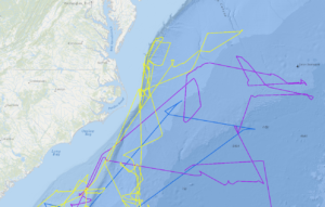
Ferry Routes and Terminals: Two new U.S. Department of Transportation maps showing the Mid-Atlantic’s robust network of ferry routes and terminals have been added to the Maritime theme in Marine Planner.
Ferry Routes and Terminals Map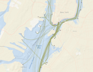
Sea Scallops 2016-2018 Potential Reproductive Output: Based on a multi-year survey by the University of Massachusetts School of Marine Science and Technology, this map characterizes Atlantic sea scallop distribution throughout their full range from the Mid-Atlantic through Canada.
Questions or comments on these items? Let us know at portal@midatlanticocean.org.
Share this:


Ferry Commuters at Atlantic Highlands, New Jersey